The pain of a tragedy is assuaged by the lessons learned from it.
That is the case with the disaster that was how the Aquino government handled the damage wrought by super typhoon Yolanda (international name: Haiyan) in November 2013.
It was a reference point in several presentations in last Wednesday’s “Earthquake Resilience Conference” organized by the Carlos P. Romulo Foundation, Zuellig Family Foundation, and the Manila Observatory at the Manila Polo Club.
*Command and control not immediately established.
* Failure to immediately secure the area.
*Inadequate emergency communication system.
* Failure to tap private sector resources immediately especially in the airlift of goods.
Director Renato U. Solidum, Jr. of the Philippine Institute of Volcanology and Seismology referred to the recent devastation in Nepal which was hit by a 7.8 intensity earthquake. More than 8,000 people were killed, hundreds were injured. Hundreds and thousands of buildings and structures were severely damaged.
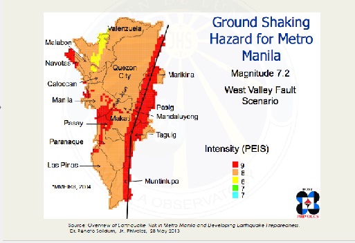
Solidum talked of the West Valley Fault system in the Philippines which had the history of having moved four times in the past 1400 years. The last major earthquake from Valley Fault was in 1658.
“Hinog na hinog na,” he warned as he enjoined all sectors to prepare Now.
The grim scenario of 7.2 magnitude earthquake in Metro Manila: 31,000 dead and over 126,000 seriously injured. An additional 18,000 people may die from fires triggered by the earthquake.
Economic damage is estimated to reach 2.23 trillion pesos. Forty per cent of buildings and residential homes in Metro Manila may be destroyed or damaged and over three million people may need to be evacuated. Of particular concern are the 4-6 million informal settlers in the metropolitan area that are most at risk in the event of a major earthquake.
Metro Manila may separate into four isolated zones based on geography. Collapsed buildings in Makati and Mandaluyong as well as the Pasig River may separate the northern and southern parts of the metropolis, while broken road networks may isolate the west and east of the capital.The capital region faces isolation due to collapsed roads and buildings as well as fires.
Former Agrarian Reform Secretary Ernesto Garilao, now president of the Zuellig Family Foundation, said cities transected by the West Valley Fault are Quezon City,Marikina, Pasig,Makati,Taguig,and Muntinlupa.
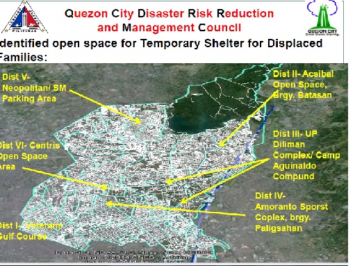
Quezon City Mayor Herbert Bautista, whose presence in the conference indicates the importance that his city gives to disaster preparation, said the barangays most vulnerable in his area of jurisdiction are Silangan, Batasan Hills, Pansol, Libis, Blue Ridge, and Ugong Norte.
He said they have started the information campaign and reported that some homeowners in middle-class subdivisions like Blue Ridge are not cooperative and are even angry about the West Valley Fault reports as it would downgrade the value of their property.
He said the government has started retro-fitting the City Hall. They are planting trees along the fault.
He shared in the conference the Contingency Plan that they have prepared for Flood and Earthquake, which includes, within the first 24 hours, coming up with a master list of affected families (children, elderly, persons with disabilities), clustering them and assigning them to their respective tents.
It also includes deployment of temporary shelter and water purifier in every identified evacuation area.
Organizational structures were presented from local to national level. It was established that in the local level, it’s the mayor that is in charge.
Considering the problem of coordination among Metro Manila mayors in other issues like traffic, one asked, in the event of a Metro Manila wide severe damage, who’s in charge?
One of the resource persons replied: The Office of the President.
In our table the collective reaction was: “Naloko na.”
Well, an informative article turned sour at the end. Who should coordinate? The Supreme Court or Senate? The Office of the President works through the cabinet, with Secretary Roxas handling a lot of the front line emergency work. He learned a lot from Yolanda too. The nation is vastly better prepared for storms than before.
It sometimes seems to me you expect the President to stop God from wreaking his natural havoc as the only way you will join his team, constructively and supportively, for the good of the Philippines.
I thought may NDRRC para sa ganitong mga nakaambang peligro.
NDRRC is now under the Office of the President, I understand.
Public Safety or NDRRC should always be under the National Govt..so as to be able to coordinate with all the local govt. the operations and logistic…and to give the comparison,..here it is…
http://www.publicsafety.gc.ca/cnt/mrgnc-mngmnt/index-eng.aspx
Kapag nangyari iyan tiyak maraming magpadala ng pera sa Pilipinas mula ibat ibang bansa at hindi lahat maipamigay. Katulad ng sa bagyong yolanda hanggang ngayon wala pa ring calamity fund para sa mga nabagyuhan ang karamihan. Maraming nasiraan ng bahay ang wala pa makatanggap ng pera na kung tawagin emergency shelter assistance o ESA. Ilang town pa lang ang nakatanggap ng tag 10,000 pesos ang bawat may ari ng bahay mula sa DSWD pero kung tutuusin kulang pa iyon pero ok na rin pag mangyari na lahat mabigyan. Kaso napakarami pa ang wala.
About Disaster Mitigation a Text Book example of proactive MEASURES…Just one of the very many…
Disaster mitigation measures are those that eliminate or reduce the impacts and risks of hazards through proactive measures taken before an emergency or disaster occurs.
One of the best known examples of investment in disaster mitigation is the Red River Floodway. The building of the Floodway was a joint provincial/federal undertaking to protect the City of Winnipeg and reduce the impact of flooding in the Red River Basin. It cost $60 million to build in the 1960s. Since then, the floodway has been used over 20 times.
Its use during the 1997 Red River Flood alone saved an estimated $6 billion.
The Floodway was expanded in 2006 as a joint provincial/federal initiative.
now for all type of hazards commons sense approach…
All-hazards approach
An all-hazards emergency management approach looks at all potential risks and impacts, natural and human-induced (intentional and non-intentional) to ensure that decisions made to mitigate against one type of risk do not increase our vulnerability to other risks.
Types of disaster mitigation
Disaster mitigation measures may be structural (e.g. flood dikes) or non-structural (e.g. land use zoning). Mitigation activities should incorporate the measurement and assessment of the evolving risk environment. Activities may include the creation of comprehensive, pro-active tools that help decide where to focus funding and efforts in risk reduction.
Other examples of mitigation measures include:
Hazard mapping
Adoption and enforcement of land use and zoning practices
Implementing and enforcing building codes
Flood plain mapping
Reinforced tornado safe rooms
Burying of electrical cables to prevent ice build-up
Raising of homes in flood-prone areas
Disaster mitigation public awareness programs
Insurance programs
ano kaya’t ang center ng west valley fault ay ‘yung batasan mismo at kapag lumindol ay bumuka ‘yung lupa habang nag-session ang pinakamasamang FAULT sa buhay ng mga botante – ang paghahalal ng mga kurakot na sinungaling at halang ang mga kaluluwang tongressmen!
Sana maunang yanigin yong spratlys at malusaw lahat ng mga ginagawa ng tsekwa sa west phuilippine sea.