
Skip to content

Tag: Antonio Carpio

Justice Carpio debunks China’s historical claim of South China Sea

Justice Antonio T. Carpio
Justice Antonio T. Carpio demolished China’s historical claims on almost the whole of South China Sea by using China’s ancient maps.

In a lecture at De La Salle University “Historical Facts, Historical Lies and Historical Rights in the West Philippine Sea”, Carpio took up China’s invitation to look at the “historical facts” by examining not only Chinese ancient maps but also maps of Philippine authorities and other nationalities.

Carpio said “All these ancient maps show that since the first Chinese maps appeared,the southern most territory of China has always been Hainan Island, with its ancient names being Zhuya, then Qiongya, and thereafter Qiongzhou. ““Hainan Island was for centuries a part of Guangdong Province until 1988 when it became a separate province,” he added.
Justice Carpio: appeal to world opinion vs Chinese defiance of the rule of law

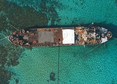
BRP Sierra Madre stuck in Ayungin Shoal, 25 miles from Mischief Reef occupied by the Chinese.
Here we go again. This time it’s over Ayungin Reef (Ren’ai Reef to the Chinese.)

The Philippine Navy reported sightings of Chinese ships in the vicinity of Ayungin shoal as early as first week of May, the last stretch of the May 13 elections, and before the May 9 incident in Balintang Channel where the Philippine Coast Guard fired upon a Taiwanese fishing vessel and killed one of the fishermen.

The Department of Foreign Affairs filed a diplomatic protest on Chinese presence near Ayungin shoal May 10.

DFA Spokesman Raul Hernandez said in their protest, they cited “the provocative and illegal presence of the Chinese government ships around Ayungin Shoal.”