Looking at the almost 300- year-old Philippine map by Fr. Pedro Murillo Velarde which businessman Mel Velarde acquired for P12 million in an auction in London last year, one can see that the Jesuit priest is a great storyteller.
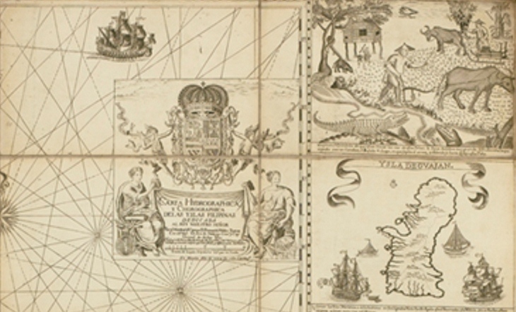
The 1734 Murillo Velarde map shows more than just locations. It has two panels on both sides engraved with images depicting lifestyles and special features of places. One panel shows a farmer plowing the field not far from a river with crocodiles. It’s noted that in Zamboanga, there’s “Pozo de Agua Dulce.” In general it showed Filipinos enjoying a highly civilized society.
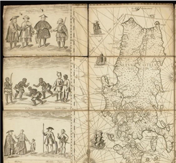
But the most significant feature of the Murillo Velarde map is a tiny spot off the shores of Nueva Castilla, which was then the name of Luzon labeled “Panacot.”
It’s a coral reef known now as Scarborough shoal, after the tea-carrying British boat Scarborough sank in the vicinity in 1784.
It is also known as Bajo de Masinloc (shoal of Masinloc). Fishermen refer to coreal reef, 124 nautical miles off Zambales, as Panatag. The Chinese which also claims the shoal, which is 467 nautical miles from its mainland calls it Huangyan Island.
I’m intrigued by Fr. Murillo’s identification of the coral reef a “Panacot”, which means fear in contrast to how the fishermen refer to it as “Panatag” which means calm.
Could it be that it was called “Panacot” because any one who ventured into the shoal would have to go through rough seas? Masinloc fishermen, on the other hand, say that they called the rock formations Panatag because it provides them a solid refuge during bad weather.
Mel Velarde, president and CEO of the Information Technology based- Now Corp and chairman of the Asian Institute of Journalism and Communication, has decided to donate the map to the National Museum since the government has no funds to buy it from him.

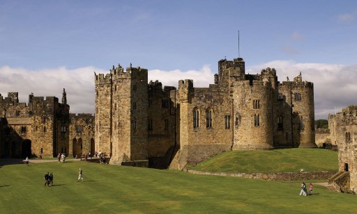
How the map by a Jesuit priest in Manila got to London and became part of the collection of the Duke of Northumberland who owns the magnificent Alnwick Castle is another interesting story.
History accounts say when British forces invaded the Philippines in 1762, they looted valuables in churches, government offices and private houses.
Historian Renato Perdon said Brigadier General William Draper, commander of British land forces, “brought to London some Spanish flags and eight copper plates which printed the celebrated Murillo Velarde Map of 1743. He donated the Spanish flags to his alma mater, Cambridge University. The copper-plates were used for some time to print copies of the Murillo Velarde Map which were sold to public libraries and cartographic collectors. One such copy was purchased by the Library of Congress, Washington, D.C.”
The Murillo Velarde map had lain together with hundreds of heirlooms collected by the Duke of Northumberland for more than 200 years in Alnwick Castle, a favorite location for period films. In the first two Harry Potter films, the castle was the Hogwarts School of Witchcraft and Wizardry.
It happened that three years ago the Northumberland County was hit by heavy rains that destroyed a culvert of the Alnwick Castle and caused severe flooding not only to the Duke’s property but also the surrounding community.
To recoup the millions that he spent for the repair of the property, the current Duke of Northumberland, Ralph George Algernon Percy, decided to have Sotheby’s auction off 80 family heirlooms which included the Murillo map.
That’s how the Murillo Velarde map was acquired by Mel Velarde.
Velarde has bought a large format printer to reproduce the map. The first copy will be presented to President Aquino on Friday as the nation celebrates Independence Day.
He would like to distribute copies of the maps to schools and in the provinces through local government units to rekindle the sense of patriotism among the young people.
“I’m also proposing a stone etch of the map in front of the Jose Rizal monument (in Rizal Park),” he said.
P12 Million donation to a country that spends billions on a parking building? This man deserves a lot of respect.
You are right, Tongue.
Pwe don’t have P12 million for something so important for our identity as a nation? There’s really something wrong with our priorities.
It’s a good thing we have people like Mel Velarde.
Correction: We don’t have P12 million for something so important for our identity as a nation?
If you want to see a clearer version of the map, go to
wdl.org (tatlong w sa harap). World Digital Library.
Search for “philippines”. The first hit will be the map. This is a digital file of the map available in the National Library of Spain, which has a copy of the Murillo map.
Right-click, and open the map in a new tab. Then, click on the map. You can zoom and see the details of the map.
The fourth hit of the search is a map made by the Dutch in 1760 (Covens and Mortier), but with French titles. It is from the National Library of Brazil. It has the same detail, about the “Bafse de Marsingola ou Panacot.”
This map states that it is a Nydrographical and Chorographical Chart of the Philippine Islands.
Free dictionary online defines “hydrographic chart” as “A nautical chart showing depths of water, nature of bottom, contours of bottom and coastline, and tides and currents in a given sea or sea and land area.”
Were the Spaniards making a claim on Panacot? Or was this only for navigation? This was in 1734, before the development of the archipelagic doctrine (UNCLOS – 1982). At that time (1734), nations only claimed 12 miles from their coastline.
There is a map available on ebay for $440 that purports to be the 1740 Albrizzi Map of the Philippines and Borneo
It does not include Panacot.
Note too, that the lower third of Palawan is labeled “Borneo”. So that belies the claim that the entire Palawan used to be owned by the Sultan of Sulu, or Sultan of Borneo.
The ebay page is found below:
ebay.com/itm/1740-Albrizzi-Map-of-the-Philippines-and-Borneo-/351411175778?pt=LH_DefaultDomain_0&hash=item51d1bd0162
Tatlong w sa harap.
Click the map below the page, and you will get the detail.
SnV,
In the Murillo map I noted that Borneo was part of the Philippines.By that time the Sultan of Brunei had already ceded part of Boreno (Sabah) to the Sultan of Sulu (1658.)
Timeline compiled by GMA7:
15th century – The Islamic sultanate of Brunei is nominally in control of Borneo, including Sabah and Sarawak states of Malaysia, and some parts of the Sulu islands in the Philippines.
1658 – The Sultan of Brunei cedes Sabah to the Sultan of Sulu in compensation for his help in settling a civil war in the Brunei Sultanate
In June 1658, Brunei Sultan Abdul Hakkul Mubin awarded the northeast coast of Borneo (Sabah), including Palawan, to Sulu Sultan Salah ud-Din Karamat Bakhtiar for helping settle a civil war dispute against Pengiran Bongsu Muhyuddin.
The Sultan of Sulu sent more than 250 elite Tausug warriors led by Panglima Ilijji (forefather of Nur P. Misuari, founder of the Moro National Liberation Front/ MNLF) to assist the Sultan of Brunei.
1673 – Brunei Sultan Bongsu Muhyuddin, upon ascending to the throne, confirms the Sultan of Sulu as sovereign landowner of the territories of North Borneo/Sabah and the island of Palawan.
1761 – Alexander Dalrymple, Madras representative of the British East India Company, entered into a lease agreement with self-proclaimed Sultan Muiz ud-Din for the rental of Sabah. The agreement permitted Dalrymple to set up a trading post on Balembangan island in Kudat North Borneo (Sabah).
Source: “Historical Timeline of the Royal Sultanate of Sulu Including Related Events of Neighboring Peoples” by Josiah C. Ang, PM
That’s why I was thinking,if the Aquino government uses the Murillo Velarde map to support its ownership of Panacot against China’s claims, how is it going to use the map vis-a-vis Sabah since he doesn’t want to ruffle the feathers of Malaysia?
At least they can use it to reclaim Guam.
Lalo nang naloko.
Are “Marsingola ou (or in French) Panacot” and Scarborough Shoal the same sea feature?
If you google “Marsingola”, the 7th hit will be a google link to the book “Complete Set of Nautical: Tables Containing All that are Requisite, with the Nautical Almanac” found in the Library of Catalonia (region of Barcelona).
If you click the google link, you will find “Marsingola Shoal” highlighted in yellow. Below it is “Boliano (Bolinao) Shoal”, and “Scarboro’ Shoal.” The latitudes and longitudes are different.
Now you go to
nhc.noaa.gov/gccalc.shtml (tatlong w sa harap), which says it is a
Latitude/Longitude Distance Calculator
You can plug in the latitudes and longitudes of Marsingola and Scarboro, and you get the distance.
I plugged in 15:13 and 119:16 for Marsingola, and 15:12 and 117:47, and the result is 159 km. You can choose the units of the results – nautical miles, statute miles, or kilometers.
The distance from Manila to Paniqui, Tarlac is 151 km.
Uy, guest pala si Ellen kasama ni Mel Velarde in Pia Hontiveros’ show in CNN Phils. about this very topic.
*very same topic
I missed the replay this afternoon. Nawala sa isip ko.
Los Bajos de Paragua, could it be? I think it was just 3 miles territorial seas before UNCLOs